A map is a very handy tool for all anglers. We definitely put it on the short list of required items along with a depth finder. It’s particularly important if you are fishing new or unfamiliar water. We’ll give you some clues to look for so you can read a map like a pro and find some new fishing spots.
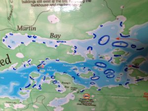
You’ll want to get or bring a depth map like this one below. The big one at the lodge is blue and green and we sell smaller durable versions for $10. We also have free paper maps with the rock reefs marked, but you’ll want the map with depths and contours on it for this exercise.
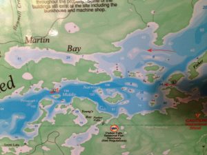
So that’s a shot from the map of the central part of the lake. The lodge is located near the bottom in the center – just to the right of the words “Parker Falls”. How do you know where to fish? There are several things I’m looking for on the map.
Wind direction
This is a major factor and it will probably change daily. For more reading on the importance of wind check out this blog from two years ago.
Don’t forget if the weather says “west wind” that means the wind is out of that direction blowing from west to east or left to right on the map. You want to fish the shoreline that the wind or blowing into or a piece of structure on the lake that the wind is blowing across.
Points
Points or fingers of land that jut out into the water provide great structure to hold fish. This structure amplifies the effects of wind and starts that feeding frenzy food chain we are looking for. If you are in a bay or driving by an island with a distinct point, it’s worth checking out. I have marked several points in Martin Bay and on various islands and parts of the main lake shoreline.
Depth Changes
Fish can be temperature sensitive and will occasionally move to deeper water. Look for spots on the map where white or very light blue meaning shallow meets dark blue areas meaning deep water. These depth changes merit some exploration. You will often find humps or reefs while checking out the sharp changes in depth.
Reefs
Find reefs, structure, sunken islands or whatever you want to call them on the main lake. There are five reefs in the center of the lake toward the right side of the picture that top out at less than ten feet deep. There is deep water nearby, but fish will move on top or to the edges of these reefs to feed.
Creeks
Fish love moving water. Moving water means additional oxygen and a terrific food source. If you target creeks, rivers, and runoff flowing into the main lake you will find fish.
Channels
Tight spots between islands or between an island and the shoreline create a food funnel particularly if the wind is blowing through the gap. The channels on the southwest side of Pictograph Island and the one I like to call the South Channel at the bottom right of the picture frequently hold fish. West or east winds push water through the channels creating a current of sorts much like a stream or river will. This will draw bait fish and then the larger fish you are searching for.
I could easily spend an entire week fishing the water included in the picture and that’s only a small section of Red Lake. There’s A LOT of water out there. Hopefully this will help you take a fresh look at that map next time, particularly if you are in an area of the lake for the first time!